
No products in the cart.

Al Hajar Mountains
If you have the knack for looking at the world around you from a Mountain Top for adventures like trekking, hiking, camping, swimming, as well as horse riding, this could be one of the nail-biting venues for you, AL HAJAR Mountains can surely be your destination.
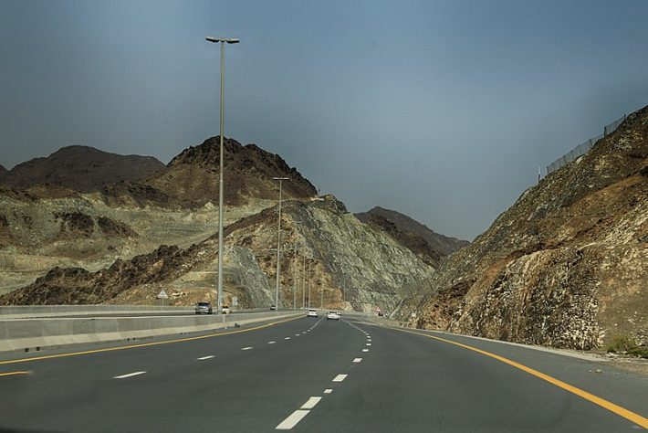
Explore a hidden GEM of UAE with a happening tour of the AL HAJAR Mountains which is just a few hours’ drives from Dubai. Feel the love & the fresh breath pervading in the air of this iconic Mountainous range.
The meaning of Al is “The” and Hajar is “Rock”.
Oman Mountains stretch around 500 Kms from North East corner of the Arabian Plate, Musandam Peninsula region to the east coast of Oman.
The Scenic drive and beauty are too captivating and impressive to miss out on, thus making it a complete tourist delight.
Therefore, visiting the highest Mountain Range of the Al Hajar Mountains is worth it will give you a lifetime experience to enjoy its beauty.
Starting from the North, The Hazar creates the Musandam Peninsula and runs up to the southeast parallel to the coast.
Jebel Akhdar is in the middle and covers most of the area. The low coastal of Jebel Hazar is Al Batinah and Ad Dahira. The climate is wet warmer and cool from December to March and occasional rain from April to September.
As we go higher, the temperature falls down to 0 degrees Celsius.
It is also rich in plant life as compared to the best part of the Arab and the vegetation varies on the altitude. There are woodlands, shrub lands, varieties of fruits, and dry fruits.
History of the Al Hajar Mountains
Mountains are generally formed when the two tectonic plates collide with each other and this process takes over millions of years. For Hazar, it is believed that they were first formed on the Arabian – Eurasian convergent plate boundary due to which continental collision occurred.
This is supposed to be formed 30 millennia ago. There are many historical spots as well as archaeological sites like Bat Al Khutm and Al Ayn which becomes highly impressive for history lovers.
Geographic Location
Geographically Hazar Mountains are divided into various sections.
- Central Hazar,
- Eastern Hazar,
- Western Hazar,
- North –Western Hazar.
Central Hazar– It covers the widest area of all. The terrain ranges from the highest to the lowest (Jebel Shams to Jebel Akhdar respectively). Jebel Nakhl reaches out to eastern low Samail valley connecting Muscat.
Eastern Hazar falls on the eastern side of Samail leading to the fishing city of Sur, in North Eastern Oman known as Al Hazar Ash-Sharqi
Western Hazar or Oman Proper are the Mountains comprising Musandam and UAE since lie on the west of the valley.
North-Western Hazar has the world’s longest zip line named Jebel Jais which is approximately 1934 meters vertically and certified by Guinness World Records.
The rock layers, four in number, consist of
- Base rocks like carbonates
- Continental shelf carbonates
- Rocks that have been displaced are known as ‘NAPPES’.
- Marine and terrestrial sedimentary rocks.
There are additional sites such as Jebel Hafeet, Hatta mountains, and Wadis.
Wadi Hatta is famous for the Hatta dam and Wadi Hatta Hub which offers horse riding and Kayaking.
Jebel Hafeet and Hatta are more popular hiking trails and wadis famous for wildlife & pools etc.
Things to do at Al Hajar Mountains
There are various activities available to an individual viz rocking climbing, trekking, swimming, camping, zip lining, and likewise
Hazar is full of historical spots like ruins of archaeological sites which can be admired by history lovers.
People interested should take their camping equipment, tools, and gears for climbing as well as trekking. People can camp anywhere other than cultivated areas and near wadis which often flood and can be dangerous.
There is a Mosque named Masjid Saad Ben Moaz and a Temple too.
You can find a variety of trees such as wild olive, fig, junipers, pomegranate, apricot, and lots of other fruit trees.
The main attraction to see are Jebel Akhdar, Jebel Sham, Jebel Hafeet, Jabreen Castle, Wadi Ghul viewpoint, Sharfat Al Alamayn viewpoint, Shams balcony walk, and Grand canyon Oman which are about 20 viewpoints.
Tune in with the musical instruments collection house at the Royal Opera House.
Hotels & food are available in plenty for food lovers who can go for Iranian Cuisine as well.
The islands and ancient hilltop villages of Fanja increase the intense curiosity of the travelers. Bargain deals for the purchase of souvenirs are also around.
Hot springs add further to the flavor.
FAQS
Which is the most popular place for camping?
Hatta.
What about the climatic conditions?
Climate is warm, wet, and dry. But as you ascend, the temperature falls below zero degrees Celsius. Summers are also chilly, therefore, tourists are recommended to take warm clothes and the necessary accessories with them.
What is the local language spoken?
Arabic, English, Hindi & Urdu
What is the pollution level?
The current air quality as on July 2023 is fair and at acceptable norms. People suffering from breathing problems may experience minor or moderate symptoms from long-term exposure.
Covid control
It is not a major issue anymore.